KiribatI
- Total Area: 811 sq km
- Land Area: 811 sq km
- Water Area: 0 sq km
- Size Comparative to U.S. territory: 4 times the size of Washington D.C.
- Bordering Bodies of Water: Pacific Ocean, London Channel
- Total Distance of all Land Boundaries: 0 km
- Total Distance of Coastline: 1,143 km
- Description of Climate: Tropical; marine, hot and humid, moderated by trade winds
- Description of Terrain: Most low-lying coral atolls surrounded by extensive reefs
- Point of Lowest Elevation: Pacific Ocean (0 m)
- Point of Highest Elevation: Unnamed elevation on Banaba (81 m)
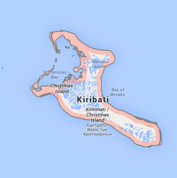
Country specific map of Kiribati
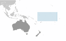
Regional map of Kiribati: Australia
Google map of Kirbati's capital: South Tarawa
